Denkars Getaway

Meri Puensum Hike

The first thing that will capture your sight when in Haa is the Meri Puensum Mountains. Meri Puensum mountain consists of three mountains and is popularly known as the three brothers. The three sharp hills that rise from the valley are the unique and prominent landmarks of Haa. Meri Puensum nature trail is located along these mountains.

Meri Puensum is given spiritual importance, and local people pay homage by circumambulating around these mountains, for they believe that the hills are embodiments of gods. Farthest north is Jampelyang (Manjushri), the middle is Chana Dorji (Vajrapani), and Chenrezig (Avalokiteshvara) is the southernmost. To protect and preserve the iconic mountains for the present and future, Meri Puensum Heritage Forest was established in an area of 563.57 hectares under Esu and Katsho Gewog in 2016. Meri Puensum hiking trail was inaugurated in commemoration of the 60th birth anniversary of His Majesty the Fourth King of Bhutan. However, not many locals and tourists have explored the nature trail as of now.

Introducing local hikers and herders

However, the beauty of those three mountains enticed me to hike the Meri Puenseum nature trail during my trip to Haa. Although I planned to do it solo, local people and my host discouraged me and warned me of encountering bears and losing the trail. I managed to contact a local hiker group from Dumcho village who is familiar with the path. Kencho Dorji, a local trained guide, accompanied me, and on the way, we were joined by a local yak herder who has lived up at the mountain for the last 12 years.

Hiking Meri Puensum Nature Trail

8 August 2018: At around 8:00 am (the third day of my stay in Haa), we started our hike from Lhakhang Karpo. The locals believe that one must begin the Meri Puensum hike by offering butter lamps and burning incense sticks in the main chapel of Lhakhang Karpo. One should also end the circumambulation of three hills by hiking till the Lhakhang Karpo. Otherwise, the three hills kora would be considered incomplete. The hike starts from a village called Dumcho (opposite the helipad). Although the town is accessible by feeder road, we walked from Lhakhang Karpo. We took 30 minutes to walk till the end of feeder road.

When we reached the end of the feeder road, the actual hiking trail started from that point in the area. Once we took the nature trail, we left the village and started ascending uphill for almost 5 hours. Well, if you are a fast walker, you could make it uphill in less than 5 hours. The initial climb was pretty challenging since it’s an uphill zig-zag climb through the pine trees. My hiker squad was very energetic and did not mind making all sorts of loud noises just in case the bear were around the vicinity. During the first few hours of hiking, we crossed several streams and bridges. By the way, don’t forget to count the bridges when you hike. From the start till the end, you will come across 13 wooden bridges, three resting areas, and three canopies in between.

The hiking trail is extensive, and Haa dzongkhag takes the initiative to maintain the track. However, initial trials are confusing because the first paved trail takes a little longer. Thus locals and hikers paved their shortcuts and have become the main route. This leaves first-time hikers confused with the path.

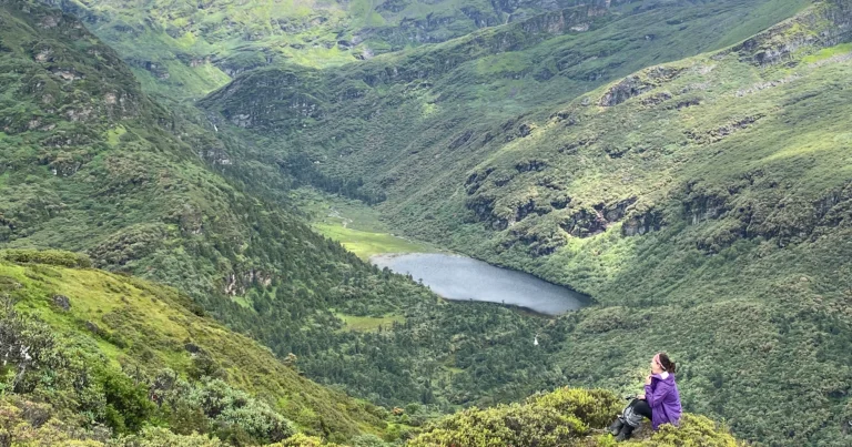
Once you reach the first canopy, the trail gets easy. As you further walk the easy path, you get to the highest peak of Meri Puensum, and that’s where you get to see the view of Chelela Pass, Meri Puensum, and the rare Jomolhari. From the hilltop, you will see green meadows and domestic animals grazing peacefully. As we kept walking, we reached the second canopy, which is the designated lunch spot. The ceiling was surrounded by wildflowers and bushes. With the fear of altitude sickness, we lit up incense sticks for fragrances. After an hour hike, we arrived at Talela (at 3600 altitudes).

A stupa marks the junction between the trail to Nubtshonapa and way back to the plains of Haa valley. From Talla, the hiking trail descends downhill. It started to rain when we arrived at that point, so the route became a little slippery. I slipped twice and bruised my arm. Downhill trail crosses the bridges and streams. After hours of descending, you reach the third canopy (the last and final resting area). We rested for a while and then proceeded downhill. From there, the route is all easy. I am good with descent, so it was an easy downhill hike, but a friend in our group had difficulty climbing down due to a knee injury.

After almost 2 hours, we reached the village opposite Gongzim Ugyen Dorji Central School. Few miles from the town, you finally get the famous suspension bridge near the village. For tourists, this marks the end of the Meri Puensum Hike.

Overall, the Meri Puensum hike was an incredible experience. We delved ourselves into the wood until up on the mountaintop. We were breathing the wilderness at 3800 meters above sea level with utter joy.  If you are travelling to Haa, the Meri Puensum hike should be included in your itinerary. After all, if you have never visited the valley, the view from the mountaintop is breathtaking.


IMG_0223
The moment with the King
The moment with the King On 3rd May 2019, I was in Thimphu couch surfing at my sister’s place. On that...
Read More
Adventure-417x500
River Rafting in Punakha
River Rafting in Punakha We have sparkling mountain streams and torrential rivers meandering through...
Read More
Slider5
Meri Puensum Hike
Meri Puensum Hike The first thing that will capture your sight when in Haa is the Meri Puensum Mountains....
Read More
Viewpoint
GELEPHU: ‘THE LAND OF THUENPA PUENZHI’
GELEPHU: ‘THE LAND OF THUENPA PUENZHI’ Gelephu under the Sarpang district is one of the ideal winter...
Read More